SSC CGL - Detailed Guide 2025
Self-Paced Course
Geographical Miscellaneous
Reference: Lucent GK, NCERT Class 6–12
Important Prehistoric Sites in India
Longest, Largest, Highest, Smallest in Geography
| Category | Feature Name | Detail / Location |
|---|---|---|
| Longest River (World) | Nile River / Amazon | Nile: Africa (6650 km); Amazon: S. America (6400+ km) |
| Longest River (India) | Ganga | 2525 km |
| Largest River by Volume | Amazon River | South America |
| Longest Mountain Range (World) | Andes | South America (~7000 km) |
| Highest Mountain Peak (World) | Mount Everest | 8848.86 m (Nepal–China border) |
| Highest Mountain Peak (India) | K2 (Godwin Austen) | 8611 m (PoK, Karakoram Range) |
| Largest Desert (World) | Antarctica Desert | Cold Desert (~14 million sq km) |
| Largest Hot Desert | Sahara | North Africa |
| Largest Delta | Sundarbans Delta | Ganga–Brahmaputra delta (India–Bangladesh) |
| Largest Lake (World) | Caspian Sea | Saltwater Lake |
| Largest Freshwater Lake | Lake Superior | North America |
| Highest Plateau | Pamir Plateau | “Roof of the World” |
| Highest Lake | Lake Titicaca | Border of Bolivia–Peru (~3812 m) |
| Longest Dam (India) | Hirakud Dam | Mahanadi River, Odisha |
| Highest Dam (India) | Tehri Dam | Bhagirathi River, Uttarakhand |
| Largest Artificial Lake | Govind Ballabh Pant Sagar (Rihand Dam) | Uttar Pradesh |
| Largest Island | Greenland | Autonomous territory of Denmark |
| Largest Island (India) | Middle Andaman | Andaman & Nicobar Islands |
National Parks in India (State-wise)
India has 106 National Parks (as of 2023). Some important ones are:
| State / UT | Famous National Parks |
|---|---|
| Madhya Pradesh | Kanha, Bandhavgarh, Pench, Satpura, Panna |
| Rajasthan | Ranthambore, Sariska, Desert National Park |
| Maharashtra | Tadoba, Sanjay Gandhi (Borivali) |
| Uttarakhand | Jim Corbett (1st NP of India), Valley of Flowers |
| Karnataka | Bandipur, Nagarhole, Bannerghatta |
| Kerala | Periyar, Silent Valley, Eravikulam |
| Tamil Nadu | Mudumalai, Guindy |
| Gujarat | Gir (Asiatic Lions), Marine National Park |
| West Bengal | Sundarbans, Buxa, Gorumara |
| Assam | Kaziranga (Rhinos), Manas |
| Bihar | Valmiki |
| Odisha | Simlipal |
| Chhattisgarh | Indravati, Kanger Valley |
| Himachal Pradesh | Great Himalayan NP, Pin Valley |
| Jammu & Kashmir | Dachigam |
| Ladakh (UT) | Hemis |
| Andaman & Nicobar Islands | Mahatma Gandhi Marine, Mount Harriet |
| Goa | Mollem (Bhagwan Mahavir) |
| Arunachal Pradesh | Namdapha |
-
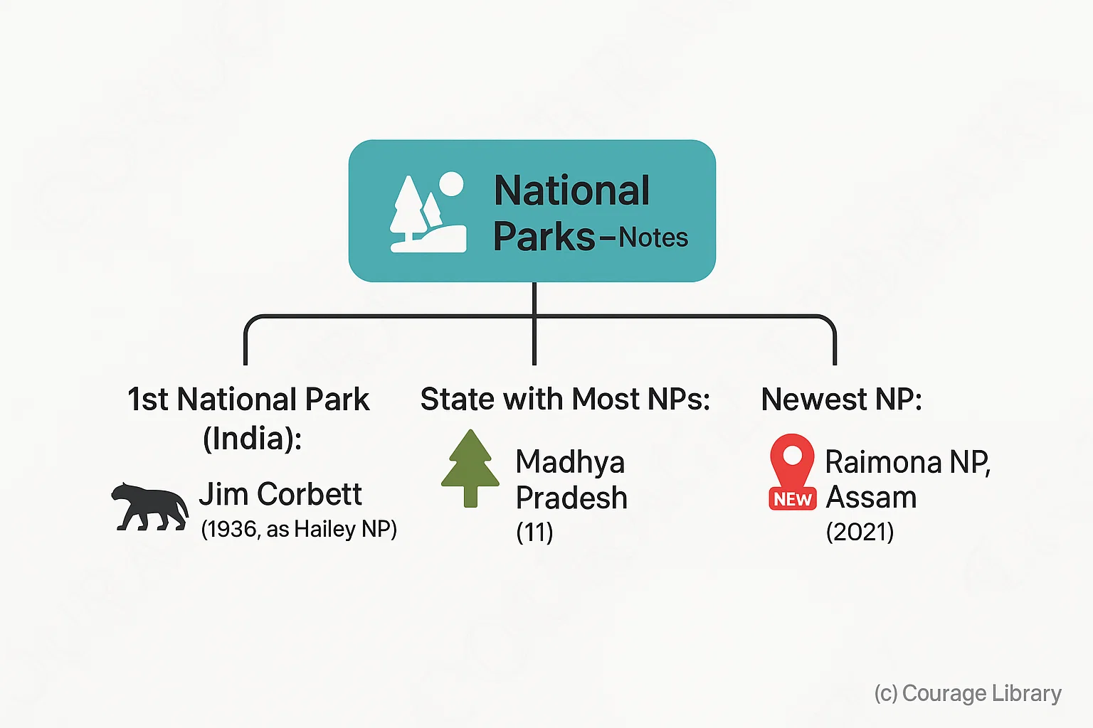
Note:
- 1st National Park of India: Jim Corbett (1936, as Hailey NP)
- State with most National Parks: Madhya Pradesh (11)
- Newest NP: Raimona NP, Assam (declared in 2021)
Important International Boundaries (Lines of Separation)
| Boundary Line | Countries Separated | Year / Details |
|---|---|---|
| Durand Line | Afghanistan – Pakistan | 1893 (British India & Afghanistan) |
| Radcliffe Line | India – Pakistan | 1947 (Partition line by Sir Cyril Radcliffe) |
| McMahon Line | India – China (Arunachal Pradesh) | 1914 (Simla Agreement; China disputes it) |
| Line of Actual Control (LAC) | India – China | Not clearly demarcated |
| Line of Control (LoC) | India – Pakistan (J&K) | Military control line, post-1947–48 war |
| Maginot Line | France – Germany | WWII Defensive Line |
| Hindenburg Line | Germany – Poland | Post WWI boundary |
| 38th Parallel | North Korea – South Korea | Post-Korean War |
| 49th Parallel | USA – Canada | Longest undefended border |
| Siegfried Line | Germany – France | Defensive line (WWII) |
-
Trick to Remember:
- D-R: Durand → Radcliffe → McMahon → LoC → LAC → international lines for India
- “R” in Radcliffe = Partition of Republics (India–Pakistan)
- “M” in McMahon = Mountains (India–China Himalayan Line)
Developed By Roopasree Challa
Next
Start Your SSC CGL Journey Now!
Join Courage Library to experience disciplined study and expert support.
Be a Couragian!